Cascade Environmental Group
  • Home
  • Portfolio
    • Clackamas Partnership Strategic Planning and Grant Development Support
    • Carli Creek Water Quality Project
    • Ghost Dike Mitigation Project
    • Kwoneesum Dam Removal
    • Salmon Superhighway Strategic Action Plan
    • Molalla River Watershed Drinking Water Assessment
    • Chum Salmon Strategic Restoration Action Plan
    • Hopkins Forest Wetland Restoration
    • Yoncalla Creek Mitigation Bank
    • Cowlitz Tribe Estuary Restoration Feasibility Studies
    • Dahl Beach Mitigation Project
    • Wapato Valley Mitigation Conservation Bank Wetland Support
    • Shoalwater Bay Mitigation Bank
    • Newell Creek Canyon
    • Fernhill NTS Wetlands
    • Elk Creek Watershed Information Gap Assessment / Stream and Fish Surveys
    • Big Hanaford Creek
    • Chehalis Basin
    • Wallooskee-Youngs
    • Mitchell Creek
    • Pine Hollow-Jackknife Creek
    • Lamprey Migration Study
    • Rinearson Natural Area
    • Garret Creek
    • Wetland Delineations
  • Staff
    • John Runyon
    • Brent Haddaway, PWS
    • Tammy Stout
    • Rod Lundberg, P.E.
    • Joy Keen
    • Olivia Morgan
  • Contact
  • News
  • Who We Work With

Salmon Superhighway Strategic Action Plan
Western Oregon

Salmon Superhighway map
Picture
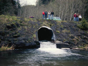
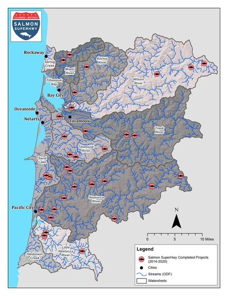
Since 2014, Salmon SuperHwy has reconnected 94 miles of key salmon and steelhead habitat within the six major Northern Oregon coast river systems by funding and completing more than 35 fish passage barriers. With a collaborative approach to reconnecting habitat, Salmon SuperHwy is an ambitious and unprecedented effort to restore access to important historical salmon habitat while enhancing Tillamook County’s road network, economic health, and public safety. The priority barrier removal projects are implemented through a unique and highly effective partnership of private and public entities, including nonprofits, businesses, local government, state, and federal agencies.
​
There are 86 stream miles left to reconnect to meet Salmon SuperHwy's ambitious goal of restoring access to 180 miles of blocked fish habitat. While many smaller or less expensive projects have been completed, the partnership needs to accelerate the pace and increase the scale of projects and funding. Salmon SuperHwy contracted with Cascade to develop a Strategic Action Plan to guide the partnership in meeting its ambitious goal. The Strategic Plan builds on the partnership's past accomplishments, organizational strengths, and lessons learned to define critical steps and funding strategies. 

Read the Salmon Superhwy 2019 Annual Report. 

Service Areas

Watershed Assessments and Restoration Planning​


info@cascadeenv.com
503-894-8585
2800 N Lombard St #803
Portland, OR 97217
Copyright 2014 Cascade Environmental Group, LLC
  • Home
  • Portfolio
    • Clackamas Partnership Strategic Planning and Grant Development Support
    • Carli Creek Water Quality Project
    • Ghost Dike Mitigation Project
    • Kwoneesum Dam Removal
    • Salmon Superhighway Strategic Action Plan
    • Molalla River Watershed Drinking Water Assessment
    • Chum Salmon Strategic Restoration Action Plan
    • Hopkins Forest Wetland Restoration
    • Yoncalla Creek Mitigation Bank
    • Cowlitz Tribe Estuary Restoration Feasibility Studies
    • Dahl Beach Mitigation Project
    • Wapato Valley Mitigation Conservation Bank Wetland Support
    • Shoalwater Bay Mitigation Bank
    • Newell Creek Canyon
    • Fernhill NTS Wetlands
    • Elk Creek Watershed Information Gap Assessment / Stream and Fish Surveys
    • Big Hanaford Creek
    • Chehalis Basin
    • Wallooskee-Youngs
    • Mitchell Creek
    • Pine Hollow-Jackknife Creek
    • Lamprey Migration Study
    • Rinearson Natural Area
    • Garret Creek
    • Wetland Delineations
  • Staff
    • John Runyon
    • Brent Haddaway, PWS
    • Tammy Stout
    • Rod Lundberg, P.E.
    • Joy Keen
    • Olivia Morgan
  • Contact
  • News
  • Who We Work With